Guess Who Came Back Bearing Gifts?

Eric’s back from his trip West. He flew to Seattle, Washington in order to ride along with a friend who was driving to Anaheim, California and back for a video gamers convention. This friend, who he met on-line, is slightly older than Eric. He’s also married, but has no kids.

I’ll admit, the first thing I thought when Eric explained the trip to me was, PEDOPHILE!

I mean, why else would a married man who plays video games (aka computer games) want my little boy to drive thousands of miles with him? I told Eric what I thought. He assured me that he knew the guy pretty well (as well as you can know an on-line friend) and that he was big enough to take care of himself.

He had a point. He is, after all, almost 20. And, like 6 feet tall. Oh yeah, he probably weighs at least 250 pounds. Besides, married men playing video games isn’t as unusual as it once was.

Anyway… Eric’s back. And he brought gifts. This is where I’d post a picture of myself smiling, if I had one handy. But I don’t. So, you’ll just have to see the gifts and imagine me sitting here grinning.
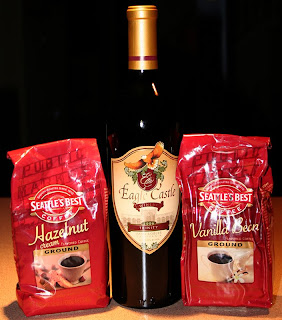
Actually, while you’re imagining the grin, try to picture my shaky fingers on the keyboard. The result of drinking an entire pot of Seattle’s Best Vanilla Bean coffee.

Yum.

Okay, I didn’t drink a whole pot. Just a mug and a half. But I have a very large mug. It’s as big as my face.

He brought back some Hazelnut coffee, too. Just like I’d ordered. So they weren’t really gifts. But he did bring back a surprise bottle of wine.

Are you thinking what I thought for a millisecond? (Great, he’s traveling with a pedophile “friend” who buys him wine, too.)

Actually, I thought the wine was a nice touch. It’s to thank me for my navigation. Which is kind of a neat idea since I apparently navigated them right past the Eagle Castle Winery in Paso Robles, California. The wine is a nice 2006 Trinity (a blend of merlot, cabernet sauvingnon and syrah).

The more I think about it, the more I think I should add a picture of me, with my coffee mug, grinning. So here ya go…
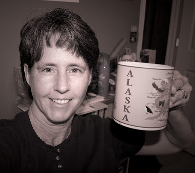
I told you it was big. I even said, “As big as my face.”

The coffee was fabulous, by the way. I’ll fill you in later on the wine, which I plan to share with some visiting friends next week.
Foolproof Swine Flu Diagnostic Tool

Now, I’m not one to panic. Yes, I know the Swine Flu is out there. Yes, I know it can hit me as easily as it can hit anyone else. I’m just not losing any sleep worrying about it.

However, I was at my doctor’s office yesterday. She told me about a paper she’d read in one of her journals that explained exactly how one can tell, without a doubt, if what ails them is the Swine Flu.

Wanna know how?

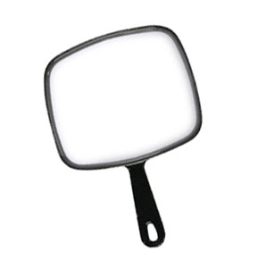
First, you need one of these.

Make sure there’s lots of light, too, ’cause you’ll have to look pretty closely.

Now, look in the mirror.

If you look like this, you’re screwed.

If you don’t look like this, you should be okay. I hope.

My Mom gets credit for e-mailing me this image, which I just had to share.

How MOMstar Knew

A couple of folks have asked how the MOMstar Navigation service knew which would be the best part of the coast to see. After all, as the post said, it’s a big coast.

Here’s what the one company official willing to provide input told us. “It’s based a lot on personal experience coupled with good mapping skills. The latter is key, but both are important.”

The same official said, “If you’ve ever visited a place after your mother has visited that same place, you’ll know, without a doubt, which spots you should see.”

Why Big Sur? Two words sum it up nicely… dramatic scenery. Here are a couple of pics from when Hubby and I visited back in 2003.

As an aside… Hubby took all of these pics with his old Sony Mavica digital camera. I was still using film.

Big Sur is a region of the central California coast. It’s where the Santa Lucia Mountains rise sharply out of the Pacific Ocean. Any time you have mountains rising sharply, especially near water, you have beautiful scenery.

Have a few minutes to kill? Watch this nice little video I found at Flickr. It has sound, too. A very catchy little tune I’ll probably be humming all day…

Remote Vacation Navigation

Let’s say you are 19 (almost 20). You’re with a friend, driving from Seattle to Anaheim and back. The trip down was hurried. For the trip back, you have a little bit of time to spare. You’ve been told you should drop by Yosemite National Park. Yet, the whole time you’ve been planning this trip, you and your friend have talked about seeing the California coast.

But California has a big coast. You’re 100 miles inland at a chain hotel off of I-5. How do you decide where on the coast to go and how to get there?

You dial the All-new MOMstar Navigation support system. Thanks to the wonders of cellular telephones and high-speed Internet in remote places like West Virginia, you call Mom and she’ll tell you what part of the coast she considers a must-see. She can tell you how to get there from your current location AND how long it should take to get where you are going.

The call goes something like this…

“Hi, Mom.” (Operators like to be called Mom.)

“Hi, son!” (It is company policy to treat customers as if they really are family.)

“I don’t think we have time to see Yosemite while we’re in California. We both really want to see the coast.”

“Where are you now, son?”

“Kettleman City.”

“Okay, let me do some figuring and I’ll call you back.”

Several minutes go by, giving you just enough time to use the bathroom, flip through about 37 cable stations, and tell your friend not to worry, “Mom” always comes through. Then the phone rings.

“Okay, son, here’s what you do. Head slightly south and over to the coast on SR-41. That will bring you to Highway 1. Turn right and head north. That will take you through Big Sur and past Monterey. Then you can go into San Francisco and drive across the Golden Gate bridge. Will that work?”

You ask Mom to hold while you consult your friend. Seconds later, you say, “That’ll be cool. Thanks, Mom.”

She gives you turn-by-turn directions, telling you that, once you hit Highway 101, to follow it through the city of San Francisco to the Golden Gate bridge. Just before you hang up, you think you hear a man in the background, who oddly enough sounds just like Dad, say, “They’ll get lost in San Francisco.”

All is well, until several hours later when driving through San Francisco, you miss a turn and end up off course. So you call Mom again.

“That’s okay, Son. Highway 101 isn’t such an easy-to-follow highway once in the city,” she assures you. She asks where you are and gets you back on course. Not only that, minutes later she calls back and asks, “Did you cross the bridge yet?”

“We’re working on it,” you tell her, kind of annoyed that she called back so soon. How could you even have gotten to the bridge that quickly?

“Okay, as soon as you do, get off at the second exit for a quick stop at the Marin Headlands. You’ll get a great view of the bridge and San Francisco from there.”

She’s been right so far, so you follow her advice. And you’re rewarded with the ultimate San Francisco vista.


You call back.

“We made it, Mom.”

“Good,” she replies. “So, is it safe for me to go to bed now?”

“Yes, thank you,” you say, since the call center is on the East Coast and it’s after 10:00 PM there.

Right before signing off, you remember to throw in, “I love you, Mom.”

“I love you, too, son,” she replies.

Just like the reviews you’d read told you, overall, using MOMstar is a good experience. A little touchy-feely, perhaps, and even a bit hokey. But it sure is convenient. And you did get to see a great view.

You Call This a Highway?

What do two motorcyclists do when there are places they want to go and it’s raining? They hop in the truck and go, of course. We saw some cool stuff, too.

The coolest and most unexpected was Capon Springs Resort in West Virginia. We were riding down what we thought was just another country lane, skirting a national forest, when we came upon this beautiful, 100-year-old resort.

It was raining, so I didn’t get many pictures. I’ll have to go back for sure. It was really quite interesting.

We’re still scoping out real estate possibilities in Virginia. Today we ended up exploring parts of Shenandoah County. Fort Valley, to be specific. Hubby plotted the route. I had no idea we’d actually be driving through a friend’s town. We’ll have to stop in for a visit next time.

The whole area was very pretty. We were very thankful that we were not on motorcycles, though, as originally planned. Because we were on lots of rough dirt/gravel roads. It seems we saw a nice chunk of the George Washington National Forest.

We were on this very narrow gravel road that I kid you not must have been chiseled into the side of the mountain. According to Hubby’s GPS, we were on “Highway” 691. It was unlike any highway I’ve ever seen, but we enjoyed it.

That’s where I snapped one of what I call my Rainy Shenandoah images. The other one is below. There’s a term for clouds hanging over valleys like this, but it has escaped me.

As we were driving, I said to Hubby, “See. If I were a Forest Ranger, I’d get paid to drive on roads like this all the time.”

He said I’d get tired of it. I think not.

Though, if I did work here, I’d have to contact the company that supplies maps to the GPS system companies. I’d send them the following image and say…

“Dude. According to you people, this is HIGHWAY 59. Does this look like a highway to you? Yeah, it’s pretty. But it should be labeled a forest road, or a gravel road, or maybe even an unimproved county road.”

It was a nice road, really, but it’s definitely not a road we’d want to be traveling on motorcycles in the rain.