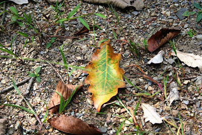
 It’s not obvious at this point. But if you look closely, you’ll see it. Some of the trees have already started changing.
 And I’ve been seeing more and more colored leaves on the ground. Actually, at higher elevations, there are quite a few maples that have already turned red.
Speaking of higher elevations…
View Romney to Aurora, WV in a larger map
If you click on the above map or link and zoom in, you should be able to see the terrain and elevation markings. You’ll have to zoom in enough to see US-50.
Why am I showing you this? So you understand why Hubby and I had a very cold bike ride on Saturday.
We wrongly decided to head west. The WV place is at about a 1,000 foot elevation. We ended up in Aurora, West Virginia, which is only about 50 miles west of Romney, but at about 2,800 feet.
It was around 70 degrees in Romney and overcast. Heading west, as soon as we hit about 1,500 feet, the temperature started dropping. And dropping. And dropping. Hubby finally stopped so we could add some layers of clothing and our gloves.
Aurora was not the planned destination. We stopped there for lunch. When we went into the restaurant, it was a little foggy. As we ate, we both agreed we’d better head back east. It’s a good thing, too. By the time we finished our meal, the temperature was hovering at 59 degrees (not so bad until you sit on a motorcycle at 60 mph!). The fog had gotten so thick that our face shields and windshields were covered with a pretty thick mist.
Not great motorcycling weather by a long stretch. We were both very happy to hit a lower elevation and warmer weather.
Luckily, Sunday was better. But I’ll talk about that in a later post.


